• This is slide 1 description. Go to Edit HTML of your blogger blog. Find these sentences. You can replace these sentences with your own words.
  • This is slide 2 description. Go to Edit HTML of your blogger blog. Find these sentences. You can replace these sentences with your own words.
  • This is slide 3 description. Go to Edit HTML of your blogger blog. Find these sentences. You can replace these sentences with your own words.
  • This is slide 4 description. Go to Edit HTML of your blogger blog. Find these sentences. You can replace these sentences with your own words.
  • This is slide 5 description. Go to Edit HTML of your blogger blog. Find these sentences. You can replace these sentences with your own words.

Jumat, 24 Juni 2016

Battery Nikon BC-65

Rp Hubungi Kami @
http://www.alatsurveymakassar.com/
Compatible Nikon Total Station Battery BC-65

Features
1. Our batteries are manufactured with top quality cells using the most up-to-date technology to ensure a long lasting charge with no memory effect. 
2. Our batteries are brand new, they are not original and they are 100% OEM compatible.
3. Works and charges the same as the original battery.
4. All of our batteries are featured with stable circuit protection, over charging protection, over heat protection and short circuit protection.
5. Comes with 12 months manufacturer warranty.
6. Safety, CE, RoHS approval.

Specifications
Description:Compatible Nikon Total Station Battery BC-65
Chemistry:Ni-MH
Output Voltage:7.2V
Capacity:    3800mAh
Dimensions (LXWXH):16.30*6.2*2.3CM
Weight:    441g
Color:    Blue
Fit Part Number:BC-65
Fit the models:Nikon DTM300/400 series/Trimble M3 total station

Battery Sokkia BDC46B

Rp Hubungi Kami @
www.alatsurveymakassar.com

Jual Battery total station sokkia 
Sokkia Total Station Battery BDC46
Features
1. Our batteries are manufactured with top quality cells using the most up-to-date technology to ensure a long lasting charge with no memory effect.  
2. Our batteries are brand new, they are not original and they are 100% OEM compatible.
3. Works and charges the same as the original battery.
4. All of our batteries are featured with stable circuit protection, over charging protection, over heat protection and short circuit protection.
5. Comes with 12 months manufacturer warranty.
6. Safety, CE, RoHS approval.

Specifications Battery BDC46
Description:    Sokkia Total Station Battery BDC46
Chemistry:    Li-ion
Output Voltage:    7.2V
Capacity:    2600mAh
Dimensions (LXWXH):    70.6mm x 37.9mmx 19.9mm
Weight:    105g
Color:    Black
Fit Part Number:    BDC46, BDC46A, BDC46B
Fit the models:    Sokkia SET 500,SET600,SET 10,SET 10K,SET 30R,SET 30RK

Haga Altimeter 6 Scale

Rp Hubungi Kami @
http://www.alatsurveymakassar.com/
pengintai optik dapat disertakan ke Haga Altimeter. Digunakan dengan multi-range target, Rangefinder ini memungkinkan Anda untuk menentukan cepat dan tepat jarak panjang dasar 15, 20, 25 atau 30 kaki, meter atau meter. Petunjuk lengkap disertakan dengan altimeter, pengintai optik, dan target multi-range.

Nikon Laser Rangefinder Forestry Pro

Rp Hubungi Kami @
http://www.alatsurveymakassar.com/
Key Features
• In addition to the conventional measurement functions, such as actual distance, horizontal distance, height, angle and vertical separation (height between two points) measurement functions, three-point measurement (height between two points) is possible.
• The results are displayed on both internal and external LCD panels. The external panel displays all results simultaneously.
• There are two measurement modes (Target Priority Switch System):
First Target Priority Mode displays the range to the nearest target taken from multiple results obtained with a single measurement.
Distant Target Priority Mode displays the range to the farthest target taken from multiple results obtained with a single measurement—especially useful for forestry and hunting.
• High-quality 6x monocular with multilayer coating produces bright images.
• Waterproof (up to 1 meter for 10 minutes) but not for underwater usage. The battery chamber is water resistant.
• High-eyepoint design allows easy viewing even with eyeglasses.
• Capable of measuring different distances in succession, for up to 20 seconds, when the button is held down.
• Measurement range: 10-500 m/11-550 yd./33-999 ft.
• Measurement can be displayed in feet as well as meters and yards.

Specifications Nikon Laser Rangefinder Forestry Pro
Measurement range    Distance: 10-500 m/11-550 yd./33-999 ft. (*999 ft.: 304.5 m/333 yd.)
Angle: ±89°
Distance display (increment)    [Internal Display]
Act (Actual Distance):
every 0.5 m/yd., 1.0 ft. (shorter than 100 m/yd./ft.)
every 1.0 m/yd., 1.0 ft. (100 m/yd./ft. and over)
Hor (Horizontal Distance) and Hgt (Height):
every 0.2 m/yd., 0.5 ft. (shorter than 100 m/yd./ft.)
every 1.0 m/yd., 1.0 ft. (100 m/yd./ft. and over)
Ang (Angle):
every 0.1° (less than 10°)
every 1.0° (10° and over)
*Downward angle from the horizontal line: with display "-"
[External Display]
Act (Actual Distance): every 0.5 m/yd., 1.0 ft.
Hor (Horizontal Distance) and Hgt (Height): every 0.2 m/yd., 0.5 ft.
Ang (Angle): every 0.1°
Finder    Magnification (x)    6
    Effective objective diameter (mm)    21
    Actual field of view (°)    6.0
    Exit pupil (mm)    3.5
    Eye relief (mm)    18.2
Dimensions (L x H x W) (mm)    130 x 69 x 45
Weight (g) (excluding battery)    210
Power source    CR2 lithium battery x 1 (DC3V)
Auto power shutoff function equipped (after 30 sec.)
Safety    Class 1M laser product (EN/IEC60825-1:2007)
EMC    FCC Part15 SubPartB class B, EU:EMC directive, AS/NZS, VCCI class B
Environment    RoHS, WEEE

Kamis, 23 Juni 2016

Panduan Singkat Penggunaan GPS MAP Garmin 78s

@
www.alatsurveymakassar.com
GPS MAP Garmin 78s

1. Cara Memulai
a. Pasang baterai.
b. Aktifkan perangkat dengan menekan tombol  “Light” (  ) yang berwarna merah.
c. Mencari satelit -> Pilih menu satelit di layar utama-> Cari posisi yang terbuka sehingga penangkapan sinyal dapat dengan mudah & cepat, setelah itu. Diamkan beberapa menit untuk mencapai akurasi satelit yang maksimum       ( antara 3m s.d 1m ).
2. Pengaturan GPS
A. Pilih “Setup/ Pengaturan” di layar utama.
B.    Setelah itu akan muncul menu lainnya dari pengaturan.
a. Sistem-> GPS ( Normal ),-> Bahasa ( Indonesia ), -> Tipe baterai ( Lithium/ Alkaline/ NiMH ),-> Interface   ( Garmi serial ).
b. Tampilan-> Waktu terang layar ( di sesuaikan sendiri ),-> Battery save ( On/ Of ),-> Warna/ Colors                                                                                                                         (di sesuaikan sendiri ).
c. Jejak-> Log  jejak ( Do not record/ Tidak merekam ),-> Metode rekam ( Otomatis ),-> Interval ( Normal ), -> Simpan otomatis/ Auto archive ( Ketika penuh/ When full ),-> Colors (di sesuaikan sendiri ).
d. Satuan -> Jarak/ Kecepatan ( Metrik ),-> Ketinggian ( meter, m/s ),-> Kedalaman ( Meter ),-> Suhu (Celsius ) ,-> Tekanan ( Milimeter Hg/ di sesuaikan sendiri ).
e. Waktu-> Format Waktu (24 jam ),-> Zona waktu ( Hongkong/ di sesuaikan menurut lokasi ),-> Hemat siang hari ( tidak ).
f. Format posisi-> Format posisi ( UTM UPS/ di sesuaikan menurut pekerjaan ),-> Datum peta ( WGS 84 )
3. Cara Membuat Titik
a. Pilih tombol “Enter” untuk membuat mark/ tanda, tekan agak lama.
b. Setelah muncul tampilan, lalu pilih “Selesai” maka otomatis titik tersebut tersimpan di “Peta” & menu “Kelola Titik”, atau anda juga bisa mengedit untuk mengganti nama titik dan simbol yang berada di atas layar.
c. Lakukan langkah a dan b untuk memulai membuat titik lagi sesuai dengan proyek anda.
4. Cara Mengukur Jarak atau Mengukur  Titik
a. Tekan tombol “Page” pada perangkat, lalu gulirkan ke menu “Peta” maka akan terlihat semua  titik yang telah anda buat tadi.
b. Tempatkan kursor di titik pertama yang akan anda ukur.
c. Selanjutnya pilih tombol “menu” pada perangkat .
d. Setelah di tekan maka akan keluar pilhan, anda enter saja “Mengukur Jarak” di pilihan tersebut.
e. Tarik kursor tersebut ke titik kedua dan tekan, maka akan terlihat jarak diantara titik tersebut.
5. Cara Mengukur Luas Area
a. Pilih menu “Kalkulasi Area” di layar utama.
b. Untuk  ketepatan penghitungan luas area, tetapkan patokan utama supaya anda dapat berhenti  ke tempat yang sama dan juga perbesar peta hingga mencapai jarak 5m.
c. Pilih “Mulai”dengan menekan tombol “Enter”, kemudian berjalan di sekeliling area yang ingin di hitung.
d. Setelah selesai dan  kembali ke posisi semula, lalu tekan “Kalkulasi” untuk melihat area yang telah di jalani.
e. Langkah terakhir di “Save” atau pilih “Ubah Unit” untuk mengedit luas area menjadi satuan
“Meter Persegi” atau pun “Hektar”.
f. Anda dapat melihat hasilnya di “Kelola Jejak”.
6. Cara Menghapus Titik atau Jejak
a. Masuk ke menu “Kelola Titik” atau “Kelola Jejak”.
b. Pilih dan enter salah satu titik atau jejak yang akan di hapus.
c. Kemudian tekan tombol “Menu” pada perangkat.
d. Lalu tekan pilihan “Hapus”.
e. Untuk menghapus semua data/ File dapat dilakukan dengan mengikuti langkah a, lalu tekan tombol “Menu”, setelah itu pilih “ Hapus Semua”.  Atau pilih “Pengaturan” , lalu tekan “Reset/ Ulang”, muncul pilihan lain, tekan           “Hapus Semua Waypoint” atau “Hapus Jejak Sekarang/ Clear Current Track”.
7. Cara Mencari Titik, Jejak, Kordinat atau Lokasi
a. Tekan tombol “Find”(Pencarian ).
b. Pilih menu ( Titik, Jejak, Kordinat, Lokasi, dll ) .
c. Setelah memilih menu yang akan anda cari, lalu” Enter” menu tersebut.
d. Pilih “Pergi” untuk menuju tujuan yang anda cari.
e. Khusus untuk mencari kordinat, masukan dulu data titik kordinat yang telah ada, lalu tekan “Selesai”.

Panduan Singkat Penggunaan GPS Garmin 64s

@
www.alatsurveymakassar.com
GPS Garmin 64s
1. Cara Memulai 
a. Pasang baterai.
b. Aktifkan perangkat dengan menekan tombol  “Light” (  ) di samping kanan perangkat.
c. Mencari satelit -> Pilih menu satelit di layar utama-> Cari posisi yang terbuka sehingga penangkapan sinyal dapat dengan mudah & cepat, setelah itu. Diamkan beberapa menit untuk mencapai akurasi satelit yang maksimum       ( antara 3m s.d 1m ).
2. Pengaturan GPS
A. Pilih “Setup/ Pengaturan” dengan menekan tombol “Enter” di layar utama.
B.    Setelah itu akan muncul menu lainnya dari pengaturan.
a. Sistem : GPS ( Normal ),-> Bahasa ( Indonesia ), -> Tipe baterai ( Lithium/ Alkaline/ NiMH ),-> Interface     ( Garmi serial ).
b. Tampilan : Waktu terang layar ( di sesuaikan sendiri ),-> Battery save ( On/ Of ),-> Warna/ Colors                                                                                                                         (di sesuaikan sendiri ).
c. Jejak : Log  jejak ( Do not record/ Tidak merekam ),-> Metode rekam ( Otomatis ),-> Interval ( Normal ), -> Simpan otomatis/ Auto archive ( Ketika penuh/ When full ),-> Colors (di sesuaikan sendiri ).
d. Satuan : Jarak Kecepatan ( Metrik ),-> Ketinggian ( meter, m/s ),-> Kedalaman ( Meter ),-> Suhu (Celsius ),  -> Tekanan ( Milimeter Hg/ di sesuaikan sendiri ).
e. Waktu-> Format Waktu (24 jam ),-> Zona waktu ( Hongkong/ di sesuaikan menurut lokasi ),-> Hemat siang hari ( tidak ).
f. Format posisi-> Format posisi ( UTM UPS/ di sesuaikan menurut pekerjaan ),-> Datum peta ( WGS 84 )
3. Cara Membuat Titik
a. Pilih tombol “Mark” untuk membuat tanda/ titik.
b. Setelah muncul tampilan, lalu pilih “Selesai” maka otomatis titik tersebut tersimpan di “Peta” & menu “Kelola Titik”, atau anda juga bisa mengedit untuk mengganti nama titik dan simbol yang berada di atas layar.
c. Lakukan langkah a dan b untuk memulai membuat titik lagi sesuai dengan proyek anda.
4. Cara Mengukur Jarak atau Mengukur  Titik
a. Tekan tombol “Page” pada perangkat, lalu gulirkan ke menu “Peta” maka akan terlihat semua  titik yang telah anda buat tadi.
b. Tempatkan kursor di titik pertama yang akan anda ukur.
c. Selanjutnya pilih tombol “menu” pada perangkat .
d. Setelah di tekan maka akan keluar pilhan, anda tekan saja “Mengukur Jarak” di pilihan tersebut.
e. Tarik kursor tersebut ke titik kedua dan tekan, maka akan terlihat jarak diantara titik tersebut.
5. Cara Mengukur Luas Area
a. Pilih menu “Kalkulasi Area” di layar utama.
b. Untuk  ketepatan penghitungan luas area, tetapkan patokan utama supaya anda dapat berhenti  ke tempat yang sama dan juga perbesar peta hingga mencapai jarak 5m.
c. Pilih “Mulai”dengan menekan tombol “Enter”, kemudian berjalan di sekeliling area yang ingin di hitung.
d. Setelah selesai dan  kembali ke posisi semula, lalu tekan “Kalkulasi” untuk melihat area yang telah di jalani.
e. Langkah terakhir di “Save” atau pilih “Ubah Unit” untuk mengedit luas area menjadi satuan 
“Meter Persegi” atau pun “Hektar”.
f. Anda dapat melihat hasilnya di “Kelola Jejak”.
6. Cara Menghapus Titik atau Jejak 
a. Masuk ke menu “Kelola Titik” atau “Kelola Jejak”.
b. Pilih dan enter salah satu titik atau jejak yang akan di hapus.
c. Kemudian tekan tombol “Menu” pada perangkat.
d. Lalu tekan pilihan “Hapus”.
e. Untuk menghapus semua data/ File dapat dilakukan dengan mengikuti langkah a, lalu tekan tombol “Menu”, setelah itu pilih “ Hapus Semua”.  Atau pilih “Pengaturan” , lalu tekan “Reset/ Ulang”, muncul pilihan lain, tekan           “Hapus Semua Waypoint” atau “Hapus Jejak Sekarang/ Clear Current Track”.
7. Cara Mencari Titik, Jejak, Kordinat atau Lokasi 
a. Tekan tombol “Find”(Pencarian ).
b. Pilih menu ( Titik, Jejak, Kordinat, Lokasi, dll ) .
c. Setelah memilih menu yang akan anda cari, lalu” Enter” menu tersebut.
d. Pilih “Pergi” untuk menuju tujuan yang anda cari.
e. Khusus untuk mencari kordinat, masukan dulu data titik kordinat yang telah ada, lalu tekan “Selesai”.

Total Station Sokkia CX-105C

Rp Hubungi Kami @
www.alatsurveymakassar.com
Jual sewa service kalibrasi Total Station Sokkia CX-105C
Specifacation Total Station Sokkia CX-105C:
Magnifications: 30X
Accuracy: 5”
Measuring Range:
Reflective Sheet ;RS90N-K:1.3 TO 500M (4.3 TO 1,640FT)
                             RS50N-K:1.3 TO 300M (4.3 TO 980FT)
                             RS10N-K:1.3 TO 300M (4.3 TO 320FT)
One Prisma; 1,3 TO 4,000M ( 4.3 TO 13,120FT)
                           Under Good Conditions:5,000M(16,400FT)
Mini Prisma: CP01 1.3 TO 2,500M (8,200FT),OR1PA: 1.3 TO 500M( 1,640FT ) 
Display: 2 Display, Graphic LCD,192 X 80 Dots
Data storage: Internal Memory; Approx. 10,000 POINTS
                            Plug-in Memory Device; USB Flash Memory ( MAX.8GB)
Bluetooth: YES ( Operating Range UP TO 300M ( 980FT)
Size With Handle:
Control panel on both Faces W191xD181xH348mm ( W7.5XD7.1XH13.7IN )
Control panel on one Face W191XD174XH348mm ( W7.5XD6.9XH13.7IN )
Weight With Battery & Tribrach: Apporx 5.6KG ( 12.3 lb )
Battery: BD70 ( Li-Ion Rechageable Battery )
Operating Time: Apporx.36 Hours

Kelengkapan Standar:
2x Alumunium Tripod
1x Pole Stik Prisma
1x Prisma Polygon
1x Prisma Single

Total Station Nikon Nivo 5C

Rp Hubungi Kami @
www.alatsurveymakassar.com
Jual sewa service kalibrasi Total Station Nikon Nivo 5C
Specifacation Total Station Nikon Nivo 5C :
Magnifications: 30X
Accuracy: 5”
Measuring Range:
Reflectorless mode (KGC18%): 200m(656FT)
Reflectorless mode (KGC90%): 300m (820FT)
One Prisma: 5,000m
Display: Face 1 QVGA,16 Bit color,TFT LCD,Backlit (320x240pixcel)
               Face 2 Backlit,graphic LCD (128x64 pixcel )
Data storage: Internal Memory; 128 MB RAM, 1GB Flash Memory
Bluetooth: YES ( Integrated Bluetooth)
Size With Handle: W149XD145XH306 mm
Weight With Battery: Apporx 3,8Kg
Battery: ( Li-Ion Rechageable Battery )
Operating Time: Apporx, 7,5 Hours

Kelengkapan Standar Total Station Nikon Nivo 5C:
2x Alumunium Tripod
1x Pole Stik Prisma
1x Prisma Polygon
1x Prisma Single

Total Station Topcon GTS-102N

Rp Hubungi Kami @
www.alatsurveymakassar.com
Jual sewa service kalibrasi Total station Topcon GTS-102N
Specifacation:
Magnifications: 30X
Accuracy: 2”
Measuring Range:
One Prisma: 2,000M
Three Prisma: 2,700M
Display: 2 Display, Graphic LCD,160 X 64 Dots
Data storage: Internal Memory; Approx. 24,000 POINTS
Size With Handle: W184XD172XH336 mm
Weight With Battery: Apporx 4,6KG
Battery: TBB-2 ( Li-Ion Rechageable Battery )
Operating Time: Apporx.9 Hours

Kelengkapan Standar:
2x Alumunium Tripod
1x Pole Stik Prisma
1x Prisma Polygon
1x Prisma Single

Total Station Topcon ES-102

Rp Hubungi Kami @
www.alatsurveymakassar.com
Jual sewa service kalibrasi total station topcon ES
Specifacation:
Magnifications: 30X
Accuracy: 2”
Measuring Range:
Reflectorless; 0.3 TO 500M ( 1.0 TO 1640FT)
Reflective Sheet ;RS90N-K:1.3 TO 500M (4.3 TO 1,640FT)
                             RS50N-K:1.3 TO 300M (4.3 TO 980FT)
                             RS10N-K:1.3 TO 300M (4.3 TO 320FT)
One Prisma; 1,3 TO 4,000M ( 4.3 TO 13,120FT)
                           Under Good Conditions:5,000M(16,400FT)
Mini Prisma: CP01 1.3 TO 2,500M (8,200FT),OR1PA: 1.3 TO 500M( 1,640FT ) 
Display: 2 Display, Graphic LCD,192 X 80 Dots
Data storage: Internal Memory; Approx. 10,000 POINTS
                            Plug-in Memory Device; USB Flash Memory ( MAX.8GB)
Bluetooth: YES ( Operating Range UP TO 300M ( 980FT)
Size With Handle:
Control panel on both Faces W191xD181xH348mm ( W7.5XD7.1XH13.7IN )
Control panel on one Face W191XD174XH348mm ( W7.5XD6.9XH13.7IN )
Weight With Battery & Tribrach: Apporx 5.6KG ( 12.3 lb )
Battery: BD70 ( Li-Ion Rechageable Battery )
Operating Time: Apporx.36 Hours

Kelengkapan Standar:
2x Alumunium Tripod
1x Pole Stik Prisma
1x Prisma Polygon
1x Prisma Single

Laser Distance Meter Leica Disto D510

Rp Hubungi Kami @
www.alatsurveymakassar.com
Jual Leica Disto D510 Laser Distance Measurer
Specifications :
• Distance measurement up to 200 m
• Minimum / maximum measurements
• Triangle / room angle function
• Area / volume measurements
• Painter function
• Trapezium function
• Pythagoras functions
• Tilt measurement 360°
• Smart Horizontal Mode™
• Sloped object measurement
• Height tracking
• Height profile measurements
• Subtraction / addition
• Pointfinder with 4x zoom
• Timer
• Personalised favourites
• Bluetooth® SMART

Kelengkapan :
1x Manual Book
1x Software

Total Station Nikon DTM-322 5"

Rp Hubungi Kami @
jual total station nikon
Jual total station nikon DTM-322 5"
SPECIFICATIONS :
Magnifications: 30X
Accuracy: 5”
Measuring Range:
Reflective Sheet ; 5X5CM 100m
With Single Prisma: 2,300m
Display: Single Face Backlit,graphic LCD (128x64 pixcel )
Data storage: Internal Memory; 25,000 POINTS
Size With Handle: W168XD173XH335 mm( 6.6in x 6.8 in x 13.2 in )
Weight With Battery: Apporx 4,8Kg
Battery: BC-65 ( Li-Ion Rechageable Battery )
Operating Time:
Apporx, 4,5 Hours ( continuous distance/ angle measurement )
Apporx, 11 Hours ( continuous distance/ angle measurement every 30 seconds)
Apporx, 22 Hours ( continuous angle measurement )

Kelengkapan Standar:
2x Alumunium Tripod
1x Pole Stik Prisma
1x Prisma Polygon
1x Prisma Single

GPS Trimble Juno 3B

Rp Hubungi Kami @
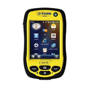
Jual GPS Trimble Juno 3B
Rugged IP54 rating for tough outdoor conditions
    Feature packed, fully integrated, affordable
    High-sensitivity GPS receiver
    5 megapixel autofocus camera with flash
    Long life battery for all-day use
    Lightweight and compact

The Trimble® Juno® 3 handheld computer is an economical solution that includes an integrated GPS, digital camera, and optional cellular connectivity.  Install the Farm Works™ Mobile software (sold separately) on the Juno to calculate field acreage, locate soil sample points by grid or zone, scout for pests or problem areas, or to collect important field records.


Built for Agriculture
With the Trimble Juno series handheld, you are empowered for every day fieldwork with a fully integrated, GPS-based data collection system.  Farmers and agribusinesses can improve their efficiency when performing GPS mapping, scouting, soil sampling, field record keeping, and other important jobs.  Data is safe and secure with its redesigned shell which is resistant to dust, water, and shock.

Choose either the Juno 3B or 3D model to suit your needs:
    Juno 3B     Juno 3D
Cellular voice & data     No     Yes
Integrated camera     5 MP     5 MP with Flash

More Features and Connectivity The next generation of the Trimble Juno series-the Juno 3B and 3D handhelds are tougher, faster, and more modern.  Each Juno handheld offers the Windows® Embedded Handheld operating system which is more intuitive and easier to navigate.
Standard wireless capabilities include built-in Bluetooth®, giving you cable-free connections to peripherals such as RFID readers and barcode scanners, and the built-in cellular modem enables you to exchange data wirelessly utilizing the Connected Farm™.  The Juno handheld gives you flexible connectivity methods to meet your farm business needs.

Included Features

    Windows® Embedded Handheld 6.5 Professional
    800 MHz Samsung processor
    256 MB RAM
    2 GB flash memory
    3.5 inch QVGA sunlight-readable color touch screen
    Integrated Bluetooth® v2.0 wireless technology
    Integrated 802.11b/g + WAPI wireless LAN
    Integrated 5 megapixel digital camera (Juno 3D has added LED Flash)
    Integrated GPS/SBAS1 receiver and antenna (2-5 meter accuracy)
    Integrated data and voice capable 3.75G cellular with SMS capability (Juno 3D only)
    1 microSD (microSDHC compatible) memory card slot
    Integrated speaker and microphone
    Long-life, rechargeable, and removable Li-Ion battery
    12-month limited warranty

Included Software

    Adobe Reader
    Microsoft® Office Mobile®, includes Excel Mobile, Word Mobile, Internet Explorer Mobile, Outlook Mobile, and PowerPoint Mobile
    Transcriber (handwriting recognition)

Included Accessories

    Rechargeable Li-Ion battery
    Stylus with lanyard
    Wrist lanyard
    USB data cable
    International AC power supply

Other Available Accessories
Trimble offers other Juno accessories that are not bundled with the Juno handheld kit, but can be purchased separately on the store.  Some of these include:

    Vehicle power supply
    Vehicle mount
    Spare/replacement batteries
    Screen protectors
    External patch antenna
    More

Physical
Size     138 mm × 79 mm × 31 cm (5.43 in × 3.11 in × 1.22 in)
Weight     0.31 kg (0.69 lb) with battery
Electrical
Processor     800 MHz Samsung processor
Memory     256 MB RAM
Data Storage     2 GB
Expansion     microSD Card slot (microSDHC compatible)
Display     8.9 cm (3.5 in) QVGA (240 x 320 pixel) resistive, sunlight readable, LED backlight
Audio     Built-in microphone and speaker, record and playback utilities
Battery     3060 mAh lithium-ion, rechargeable in unit
Power     Low (no GPS, backlight ON). -- 14 hours
    Normal (with GPS and backlight ON) . -- 10 hours
  I/O     USB client v2.0 compliant
Radios   
Bluetooth v2.0, Wi-Fi 802.11b/g
rated HSPA+ 3.75G cellular (data and voice, Juno 3D only)
  Digital Camera     5 megapixel color camera with autofocus
JPEG photo format, WMV video format, flash (Juno 3D only)
Environmental Specifications
Operating Temperature     –20 ºC to +60 ºC (–4 ºF to 140 ºF)
Storage Temperature     –40 ºC to +70 ºC (–40 ºF to 158 ºF)
Humidity limit     95% RH, non-condensing
Drop     1.2 m (4 ft) drop plywood over concrete
2 drops per 6 sides at ambient temperature 23 ºC (73 ºF)
Tumble     100 cycles (200 drops) x 50 cm (1.64 ft), 10 cycles/minute
Casing     IP54
GPS
Channels     12 (L1 code only)
Integrated real-time     SBAS
Update rate     1 Hz
Time to first fix     30 seconds (typical)
Protocols     SiRF, NMEA-0183
Accuracy After Differential Correction
Code Postprocessed     2–5 m
Real-time (SBAS)     2–5 m

Kelengkapan:
1x Main unit
1x USB Data cable
1x Wrist lanyard
1x AC power supply
1x Stylus with lanyard
1x Li-ion battery
Bonus : 1x External patch antenna

GPS Trimble Juno 5B

Rp Hubungi Kami @
Jual gps trimble juno di makassar
Jual Gps Trimble Juno 5B
Work smart with smartphone-inspired mobile GIS Your team will perform better when they've got the tools they need to get the job done. Trimble® Juno® 5 series handhelds combine must have functionality with the familiarity of a smartphone form-factor.
Compatible with GIS-oriented Trimble workflows, the Juno 5 is the smart solution your team can trust for standardizing inspections and asset management.

Your flexible, real world asset management and GIS update tool
The Trimble Juno 5 series is the smart integrated solution for your field workers, to keep them connected and in touch.
As part of the Trimble family of GPS solutions, Juno 5 series handhelds are compatible with Trimble Mapping & GIS software, giving you a choice of GIS data collection and asset management software solutions at a range of price points.
You can easily deploy the Juno 5 series alongside your current Trimble equipment and maintain the same workflows and policies.
To discuss the benefits of using Trimble Juno 5 series handhelds, contact your local Trimble reseller.
 Key Features

    Familiar, easy-to-use, smartphone form factor
    Works with professional software for GIS workflows
    Big, sunlight readable screen
    Stay in touch with the office—integrated communications available
    Rugged for work in all conditions
    1D/2D barcode scanner, RFID and enhanced GPS versions available

Bringing GIS out to the field
Perfect for asset management and data maintenance projects, everything is integrated into a convenient, rugged package: high-sensitivity GNSS, Windows® Embedded Handheld operating system, Office applications, camera, and cellular connectivity.
Stay flexible and connected with the optional built-in communications to send and receive calls and data on the job, keeping your team productive, informed, and in touch.
Using the professional workflows of Trimble field and office software, you can work with confidence in the data you are capturing.
A smarter approach to field productivity
It may look like a smartphone, but the Juno 5 series is all business. Rugged enough to meet military specs, with an IP65 rating, it has a large screen so you can easily view data or photos even in direct sunlight.
You can be confident that your teams have a real, professional tool—built to work in even the toughest conditions.
Options for flexibility
With enhanced GPS in real time, 1D or 2D barcode or RFID options to choose from, the Juno 5 series can meet whatever your workflow needs.

The Trimble Juno 5 combines the convenience of a smartphone with professional rugged design, for true confidence in the field. This makes the Trimble Juno 5 series the tool of choice for flexible, real world asset management and GIS data updates

STANDARD FEATURES
System

    Integrated 3.75G cellular data, text, and voice capability (Juno 5D only)
    8 megapixel camera with geotagging and dual LED flash
    High-sensitivity GPS/SBAS
    receiver and antenna
    Bluetooth
    version 2.1 with enhanced data rate
    Wi-Fi (802.11b/g/n)
    Multi-touch 4.3 inch WVGA sunlight-readable Gorilla
    glass display
    Long-life, rechargeable Li-Ion battery
    800 MHz (Juno 5B) or 1.0 GHz (Juno 5D and Juno 5B/5D with Barcode scanner,
    Enhanced GPS and RFID) OMAP DM3730
    512 MB RAM
    8 GB (Juno 5B), 16 GB (Juno 5D), or 32 GB (Juno 5B/5D with Barcode scanner,
    Enhanced GPS and RFID) Flash storage
    MicroSD memory card slot (supports SDHC up to 32 GB)
    Integrated speaker and microphone

Operating System

    Windows Embedded Handheld 6.5 in Chinese (Simplified), English, French,German, Italian, Japanese, Korean, Portuguese (Brazilian), Russian, or Spanish
    Android 4.1 “Jelly Bean” (available on selected configurations)

Barcode scanner
1D symbologies:EAN/UPC, GS1 Databar (limited expanded & omni-directional),Code 39, Code 128, UCC/EAN 128, ISBN, ISBT, Interleaved/Matrix/ Industrial andStandard 2 of 5, Codabar, Code 93/93i, Code 11, MSI, Plessey, Telepen, postalcodes (Australian Post, BPO, Canada Post, Dutch Post, Japan Post, PostNet,Sweden Post)
2D symbologies:Data Matrix, PDF417, Micro PDF 417, Codablock, Maxicode,QR, Aztec

Kelengkapan :
1x Main unit
1x USB Data cable
1x Wrist lanyard
1x AC power supply
1x Stylus with lanyard
1x Li-ion battery
Bonus : 1x External patch antenna

Rabu, 22 Juni 2016

Automatic Level Topcon AT-B3

Rp Hubungi Kami @
Jual waterpass topcon di makassar
Jual sewa service kalibrasi automatic level topcon AT-B3
AT-B Series – Auto Level
Utilizing a finely tuned magnetic damping system, AT-B series automatic levels quickly level and stabilize the line of sight. These precision instruments ensure reliable leveling even when working near heavy equipment or busy highways where fine vibrations could be present. The automatic levels feature IPX6 protection against powerful water jets from all directions and are fully resistant to driving rain and splashing water.
Horizontal angles can be directly read in 1º or 1gon units. Free rotation feature allows you to read any angle from zero. The circle is covered for protection against dirt and scratch. The readout window is located below the eyepiece for quick reading.
AT-B Series Features:

    •    Durable, Dependable, High Value Auto Levels
    •    3 Models - 32x, 28x, and 24x Magnifications
    •    Rapid, Accurate, and Stable Automatic Compensation
    •    Ultra-Short 20cm (7.9 in.) Focusing
    •    All-Weather Dependability
    •    Clampless, Endless Fine Horizontal Adjustments

Rapid, Stable, and Durable Compensator
The compensator of AT-B Series incorporates four suspension wires made of super-high-tensile metal that features minimal thermal expansion coefficient, providing unmatched durability and accuracy. Finely tuned magnetic damping system quickly levels and stabilizes the line of sight despite the fine vibrations present when working near heavy equipment or busy roadways.
Horizontal Circle for Angle Measurement
Horizontal angles can be directly read in 1º or 1gon units. Free rotation feature allows you to read any angle from zero. The circle is covered for protection against dirt and scratch. The readout window is located below the eyepiece for quick reading.
20cm (7.9 in.) - Ultra-Short Minimum Focus
The AT-B Series can focus on objects at 20cm (7.9 in.) in front of the telescope. This feature dramatically facilitates the works in confined spaces.


Spesifikasi - Topcon AT-B3 Automatic Level
 The AT B3, features:
•28x magnification
•36mm Objective Lens Diameter
•+/- 1.5mm accuracy (1km Double level run)
•IPX6 Water Protection
•Peep sight

The AT B3 quickly levels and stabilizes the line of sight with its finely tuned magnetic damping system, in spite of any fine vibrations present when working near heavy equipment or busy highways.
The IPx6 rating ensures reliability under all environmental conditions. The instrument is protected against powerful water jets from all directions, making it fully resistant to driving rain and splashing water.

Kelengkapan Standar:
1x Alumunium Tripod
1x Rambu Ukur 3m

Automatic Level Sokkia B20

Rp Hubungi Kami @
www.alatsurveymakassar.com
Jual Sewa service kalibrasi Automatic level sokkia B20 
Sokkia B series automatic levels feature enhanced reliability under all environmental conditions. Tough and compact bodies are more tightly sealed against water, humidity and dust (IPx6). The B series levels provide quick setup, easy sighting, and superior durability against vibration and shock, ensuring the increased productivity over an extra-long period of time.

Features
Precise, Reliable Automatic Compensator
The B series levels incorporate the most precise and reliable compensator available in the market today. The technological superiority of the Sokkia automatic levels has been proven since the release of the best-selling B2 model in 1963. Four super-high-tensile suspension wires and magnetic damping system ensure accuracy and stability even when exposed to temperature changes, vibrations, or shock.

Superior Telescope
Optimally designed telescope provides exceptionally bright and sharp view that reduces operator's eye strain. Ultra-short focus distance of 20cm (7.9in.) from end of telescope makes it easiest to use in confined locations. The B20 Model has a Two-speed focus knob switches between coarse and fine for even faster operation.

Quick Collimation
Two knobs of endless horizontal motion drives can be operated with either hand for fast and easy aiming.

Horizontal Angle Measurement
Horizontal angles can be read in 1° or 1 gon units. Freely rotatable circle allows any angle reading from zero. Right angles can be quickly set for layout and alignment tasks. The readout window is conveniently located on the instrument base - directly below the eyepiece.

Stadia
The stadia lines on the reticle allow distance measurements. Simply multiply the staff length between the top and bottom stadia lines by 100.

Easy to Adjust
Reticle adjustment is made with one screw. Circular levels vial is adjusted with two screws. Both adjustments are simple and fast with provided tools.

Spesifikasi - Automatic Level Sokkia B20
Model    B20
Telescope
Length    215mm (8.46in.)
Magnification    32x
Objective aperture    42mm (1.65in.)
Resolving power    3"
Field of View
(at 100m/328ft.)    1°20'
(2.3m / 7.5ft.)
Minimum focus    0.2m (7.9in.) from end of telescope
0.3m (1ft.) from instrument center
Image    Erect
Reticle pattern    Wedge
Stadia constant    0
Stadia ratio    100
Focusing knob    2-speed
Sighting aid    Peep sight
Lens hood    Retractable
Accuracy (standard deviation for 1km double run leveling)
Without micrometer    0.7mm
(0.03in.)
With micrometer    0.5mm
(0.02in.)
Compensator
Type    Pendulum compensator with magnetic damping system
Setting accuracy    0.3"
Working range    ±15'
Circular level
Sensitivity    10' / 2mm
Mirror    Pentaprism
Horizontal circle
Diameter    103mm (4.1 in.)
Graduations    1° / 1gon
General
Horizontal motion drive    Clampless, endless, double-sided knobs
Water resistance    IPX6 (EC 60529:2001)
Operating temperature    -20 to +50°C (-4 to +122°F)
Width    130mm (5.12in.)
Length    215mm (8.46in.)
Height    140mm (5.51in.)
Weight    1.85kg (4.1 lb.)

Kelengkapan Standar:
1x Alumunium Tripod
1x Rambu Ukur 3m

Selasa, 21 Juni 2016

GPS Trimble Juno 5D

Rp Hubungi Kami @
Work smart with smartphone-inspired mobile GIS Your team will perform better when they've got the tools they need to get the job done. Trimble® Juno® 5 series handhelds combine must have functionality with the familiarity of a smartphone form-factor.
Compatible with GIS-oriented Trimble workflows, the Juno 5 is the smart solution your team can trust for standardizing inspections and asset management.

Your flexible, real world asset management and GIS update tool
The Trimble Juno 5 series is the smart integrated solution for your field workers, to keep them connected and in touch.
As part of the Trimble family of GPS solutions, Juno 5 series handhelds are compatible with Trimble Mapping & GIS software, giving you a choice of GIS data collection and asset management software solutions at a range of price points.
You can easily deploy the Juno 5 series alongside your current Trimble equipment and maintain the same workflows and policies.
To discuss the benefits of using Trimble Juno 5 series handhelds, contact your local Trimble reseller.
 Key Features

    Familiar, easy-to-use, smartphone form factor
    Works with professional software for GIS workflows
    Big, sunlight readable screen
    Stay in touch with the office—integrated communications available
    Rugged for work in all conditions
    1D/2D barcode scanner, RFID and enhanced GPS versions available

Bringing GIS out to the field
Perfect for asset management and data maintenance projects, everything is integrated into a convenient, rugged package: high-sensitivity GNSS, Windows® Embedded Handheld operating system, Office applications, camera, and cellular connectivity.
Stay flexible and connected with the optional built-in communications to send and receive calls and data on the job, keeping your team productive, informed, and in touch.
Using the professional workflows of Trimble field and office software, you can work with confidence in the data you are capturing.
A smarter approach to field productivity
It may look like a smartphone, but the Juno 5 series is all business. Rugged enough to meet military specs, with an IP65 rating, it has a large screen so you can easily view data or photos even in direct sunlight.
You can be confident that your teams have a real, professional tool—built to work in even the toughest conditions.
Options for flexibility
With enhanced GPS in real time, 1D or 2D barcode or RFID options to choose from, the Juno 5 series can meet whatever your workflow needs.

The Trimble Juno 5 combines the convenience of a smartphone with professional rugged design, for true confidence in the field. This makes the Trimble Juno 5 series the tool of choice for flexible, real world asset management and GIS data updates

STANDARD FEATURES
System

    Integrated 3.75G cellular data, text, and voice capability (Juno 5D only)
    8 megapixel camera with geotagging and dual LED flash
    High-sensitivity GPS/SBAS
    receiver and antenna
    Bluetooth
    version 2.1 with enhanced data rate
    Wi-Fi (802.11b/g/n)
    Multi-touch 4.3 inch WVGA sunlight-readable Gorilla
    glass display
    Long-life, rechargeable Li-Ion battery
    800 MHz (Juno 5B) or 1.0 GHz (Juno 5D and Juno 5B/5D with Barcode scanner,
    Enhanced GPS and RFID) OMAP DM3730
    512 MB RAM
    8 GB (Juno 5B), 16 GB (Juno 5D), or 32 GB (Juno 5B/5D with Barcode scanner,
    Enhanced GPS and RFID) Flash storage
    MicroSD memory card slot (supports SDHC up to 32 GB)
    Integrated speaker and microphone

Operating System

    Windows Embedded Handheld 6.5 in Chinese (Simplified), English, French,German, Italian, Japanese, Korean, Portuguese (Brazilian), Russian, or Spanish
    Android 4.1 “Jelly Bean” (available on selected configurations)

Barcode scanner
1D symbologies:EAN/UPC, GS1 Databar (limited expanded & omni-directional),Code 39, Code 128, UCC/EAN 128, ISBN, ISBT, Interleaved/Matrix/ Industrial andStandard 2 of 5, Codabar, Code 93/93i, Code 11, MSI, Plessey, Telepen, postalcodes (Australian Post, BPO, Canada Post, Dutch Post, Japan Post, PostNet,Sweden Post)
2D symbologies:Data Matrix, PDF417, Micro PDF 417, Codablock, Maxicode,QR, Aztec

Kelengkapan :
1x Main unit
1x USB Data cable
1x Wrist lanyard
1x AC power supply
1x Stylus with lanyard
1x Li-ion battery
Bonus : 1x External patch antenna

GPS Trimble Juno 3D

Rp Hubungi Kami @
Jual gps trimble juno
  Rugged IP54 rating for tough outdoor conditions
    Feature packed, fully integrated, affordable
    High-sensitivity GPS receiver
    5 megapixel autofocus camera with flash
    Long life battery for all-day use
    Lightweight and compact

The Trimble® Juno® 3 handheld computer is an economical solution that includes an integrated GPS, digital camera, and optional cellular connectivity.  Install the Farm Works™ Mobile software (sold separately) on the Juno to calculate field acreage, locate soil sample points by grid or zone, scout for pests or problem areas, or to collect important field records.


Built for Agriculture
With the Trimble Juno series handheld, you are empowered for every day fieldwork with a fully integrated, GPS-based data collection system.  Farmers and agribusinesses can improve their efficiency when performing GPS mapping, scouting, soil sampling, field record keeping, and other important jobs.  Data is safe and secure with its redesigned shell which is resistant to dust, water, and shock.

Choose either the Juno 3B or 3D model to suit your needs:
    Juno 3B     Juno 3D
Cellular voice & data     No     Yes
Integrated camera     5 MP     5 MP with Flash

More Features and Connectivity The next generation of the Trimble Juno series-the Juno 3B and 3D handhelds are tougher, faster, and more modern.  Each Juno handheld offers the Windows® Embedded Handheld operating system which is more intuitive and easier to navigate.
Standard wireless capabilities include built-in Bluetooth®, giving you cable-free connections to peripherals such as RFID readers and barcode scanners, and the built-in cellular modem enables you to exchange data wirelessly utilizing the Connected Farm™.  The Juno handheld gives you flexible connectivity methods to meet your farm business needs.

Included Features

    Windows® Embedded Handheld 6.5 Professional
    800 MHz Samsung processor
    256 MB RAM
    2 GB flash memory
    3.5 inch QVGA sunlight-readable color touch screen
    Integrated Bluetooth® v2.0 wireless technology
    Integrated 802.11b/g + WAPI wireless LAN
    Integrated 5 megapixel digital camera (Juno 3D has added LED Flash)
    Integrated GPS/SBAS1 receiver and antenna (2-5 meter accuracy)
    Integrated data and voice capable 3.75G cellular with SMS capability (Juno 3D only)
    1 microSD (microSDHC compatible) memory card slot
    Integrated speaker and microphone
    Long-life, rechargeable, and removable Li-Ion battery
    12-month limited warranty

Included Software

    Adobe Reader
    Microsoft® Office Mobile®, includes Excel Mobile, Word Mobile, Internet Explorer Mobile, Outlook Mobile, and PowerPoint Mobile
    Transcriber (handwriting recognition)

Included Accessories

    Rechargeable Li-Ion battery
    Stylus with lanyard
    Wrist lanyard
    USB data cable
    International AC power supply

Other Available Accessories
Trimble offers other Juno accessories that are not bundled with the Juno handheld kit, but can be purchased separately on the store.  Some of these include:

    Vehicle power supply
    Vehicle mount
    Spare/replacement batteries
    Screen protectors
    External patch antenna
    More

Physical
Size     138 mm × 79 mm × 31 cm (5.43 in × 3.11 in × 1.22 in)
Weight     0.31 kg (0.69 lb) with battery
Electrical
Processor     800 MHz Samsung processor
Memory     256 MB RAM
Data Storage     2 GB
Expansion     microSD Card slot (microSDHC compatible)
Display     8.9 cm (3.5 in) QVGA (240 x 320 pixel) resistive, sunlight readable, LED backlight
Audio     Built-in microphone and speaker, record and playback utilities
Battery     3060 mAh lithium-ion, rechargeable in unit
Power     Low (no GPS, backlight ON). -- 14 hours
    Normal (with GPS and backlight ON) . -- 10 hours
  I/O     USB client v2.0 compliant
Radios    
Bluetooth v2.0, Wi-Fi 802.11b/g
rated HSPA+ 3.75G cellular (data and voice, Juno 3D only)
  Digital Camera     5 megapixel color camera with autofocus
JPEG photo format, WMV video format, flash (Juno 3D only)
Environmental Specifications
Operating Temperature     –20 ºC to +60 ºC (–4 ºF to 140 ºF)
Storage Temperature     –40 ºC to +70 ºC (–40 ºF to 158 ºF)
Humidity limit     95% RH, non-condensing
Drop     1.2 m (4 ft) drop plywood over concrete
2 drops per 6 sides at ambient temperature 23 ºC (73 ºF)
Tumble     100 cycles (200 drops) x 50 cm (1.64 ft), 10 cycles/minute
Casing     IP54
GPS
Channels     12 (L1 code only)
Integrated real-time     SBAS
Update rate     1 Hz
Time to first fix     30 seconds (typical)
Protocols     SiRF, NMEA-0183
Accuracy After Differential Correction
Code Postprocessed     2–5 m
Real-time (SBAS)     2–5 m

Kelengkapan:
1x Main unit
1x USB Data cable
1x Wrist lanyard
1x AC power supply
1x Stylus with lanyard
1x Li-ion battery
Bonus : 1x External patch antenna